Areas
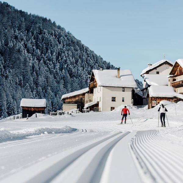
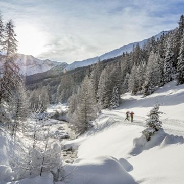
232 Kilometres of cross-country skiing trails - 3 Countries - 1 Ticket
Discover up-to-date information, practical services, and much more with the interactive cross-country ski trail map Terra Raetica.

!!!! The Reschenloipe is no longer groomed due to the temperatures !!!!
From the lakeside "Gandlan" over flat meadow area at Altdorf and the Pofellift over. After 300m it comes down to the border. From there you have the opportunity to continue across to Nauders or loops back to Reschen. Difference in altitude: 45 m Difficulty: easy
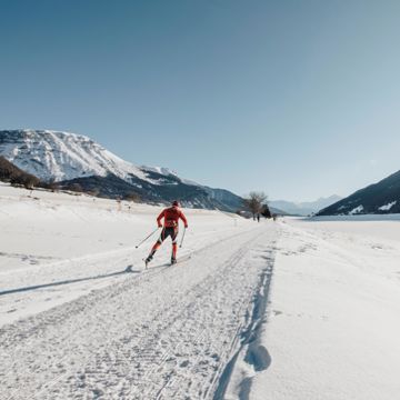
A really "unlimited" Cross-Country Fun offers the three-country ski trail between Italy and Austria to Switzerland!
Characterising the cross-country skiing trail in Solda is easy. It is a simple but fascinating route at 1,900 m above sea level with views of the Ortler, Cevedale and Königspitze mountains. With the certainty of snow throughout the winter, the 4,8 km long, high altitude trail in Solda is sure to excite skating and classic cross-country skiers. The high altitude trail in Solda is groomed from the middle of December to the middle of April. The ticket can be purchased directly at the valley station of the Kanzellift, at the valley station of the cable car, at Sport Thöni or at the information office. You will find parking spaces directly at the Kanzellift or at the entrance to the village.
Characterising the cross-country skiing trail in Solda is easy. It is a simple but fascinating route at 1,900 m above sea level with views of the Ortler, Cevedale and Königspitze mountains. With the certainty of snow throughout the winter, the 4,8 km long, high altitude trail in Solda is sure to excite skating and classic cross-country skiers. The high altitude trail in Solda is groomed from the middle of December to the middle of April. The ticket can be purchased directly at the valley station of the Kanzellift, at the valley station of the cable car, at Sport Thöni or at the information office. You will find parking spaces directly at the Kanzellift or at the entrance to the village.
The Monterodes trail is a classic and skating trail in the cross-country skiing centre of Schlinig.
Length: 1 km
Metres in altitude uphill: 15 m
Level of difficulty: easy/blue
The Fölla trail is a classic and skating trail in the cross-country skiing centre of Schlinig.
Length: 4 km
Metres in altitude uphill: 70 m
Level of difficulty: easy/blue
The Sesvenna trail is a classic and skating trail in the cross-country skiing centre of Schlinig.
Length: 6 km
Metres in altitude uphill: 125 m
Level of difficulty: medium/red
The Rasass trail is a classic and skating trail in the cross-country skiing centre of Schlinig.
Length: 2 km
Metres in altitude uphill: 30 m
Level of difficulty: easy/blue
The alpine pasture trail is a classic and skating trail in the cross-country skiing centre of Schlinig.
Length: 9 km
Metres in altitude uphill: 150 m
Level of difficulty: hard/black
Cross country skiing is an intensive and relaxing experience in the unspoiled nature. The sunny Slingia valley welcomes you with perfectly preapred slopes. Beginners and professionales find best conditions on 22 km slopes.
The cross-country skiing trail in Schmelz, starting at the Hotel Waldheim at 1520m, is a forest hiking trail. Here it is allowed to hike on the cross-country trail, to go sledding and dogs are also allowed, but must be kept on a leash.
Please give priority to cross-country skiers!
The cross-country skiing trail in Schmelz, starting at the Hotel Waldheim at 1520m, is a forest hiking trail. Here it is allowed to hike on the cross-country trail, to go sledding and dogs are also allowed, but must be kept on a leash.
Please give priority to cross-country skiers!
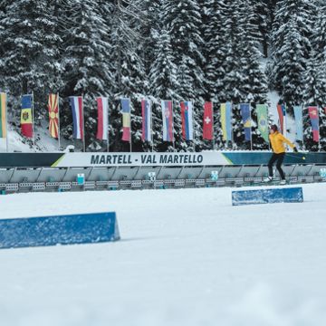
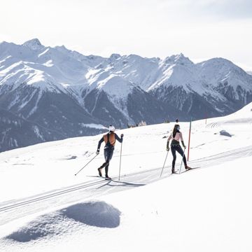
Applies to all trails in the biathlon center: suitable for classic and skating
Starting point: at the Biathlon Center Grogg from 1700 m
Challenging loop with the legendary Fragolino, which with its long climb and technically difficult descent, is one of the most difficult sections in the biathlon circuit.
Recommended only for advanced cross-country skiers! Height difference: 60 m
Applies to all trails in the biathlon center: suitable for classic and skating
Starting point: at the Biathlon Center Grogg from 1700 m
The 2 km loop leads from the biathlon stadium first 1km flat along the orographically left side of the Plima, where you then immediately turn right. After another flat passage, a steep and demanding climb follows. After that, the trail is flat again until the snow depot, where an easy descent follows. Then you run flat again with two short crisp climbs towards the biathlon stadium.
Height difference: 50 m
Applies to all trails in the biathlon center: suitable for classic and skating
Starting point: at the Biathlon Center Grogg from 1700 m
1 km:
Largely flat trail, without technically difficult climbs and descents. Ideal for beginners. Difference in altitude: 20 m
2 km:
The 2 km loop leads from the biathlon stadium first 1km flat along the orographically left side of the Plima, where you then immediately turn right. After another flat passage, a steep and demanding climb follows. After that, the trail is flat again until the snow depot, where an easy descent follows. Then you run flat again with two short crisp climbs towards the biathlon stadium.
Height difference: 50 m
3,3 km:
Challenging loop with the legendary Fragolino, which with its long climb and technically difficult descent, is one of the most difficult sections in the biathlon circuit.
Recommended only for advanced cross-country skiers!
Height difference: 60 m
4 km:
The longest loop in the biathlon center for advanced cross-country skiers with technically challenging climbs and descents, but also flat gliding sections.
Height difference: 60 m
Die anspruchsvollere Rundloipe.
Die Loipe führt vom Langlaufzentrum unterhalb von Fuldera Richtung Fuldera d'Aint. Von Palüds bis Fuldera d'Aint und zurück zum Langlaufzentrum, welche oberhalb Lü führt, ist ein wenig mehr Kondition gefragt.
Höhenloipe auf der Sonnenterrasse Lü (1920 m ü.M.) mit einzigartigem Ausblick zum Ortlermassiv.
Langlaufen in der Heimat von Olympiasieger Dario Cologna: Die Loipe zwischen Tschierv und Valchava schlängelt sich in einer angenehmen Steigung abwechslungsweise durch Tannen- und Lärchenwälder dem malerischen Rombach entlang.
Das Val Müstair, Heimat von Langlauf-Superstar Dario Cologna und seinem Bruder Gianluca, liegt in der südöstlichsten Ecke Graubündens und erstreckt sich zwischen dem Ofenpass und dem italienischen Vinschgau. Auch dank der Popularität der Cologna-Brüder mausert sich das Gebiet immer mehr zum Langlauf-Eldorado.Die anspruchsvolle Talloipe startet in Valchava. Bei Fuldera führt die Spur durch den Wald und dann weiter über die Ebene von Palüds. Stets dem malerischen Rombach entlang, geht es bis nach Tschierv. Der Einstieg ist in Valchava, Fuldera und Tschierv möglich.Regelmässig gastiert die Tour de Ski, ein Wettbewerb im Skilanglauf über mehrere Tage, im Val Müstair. Für besonders Hartgesottene bietet die «Tour de Ski»-Loipe zum Schluss in Tschierv den Höhepunkt eines perfekten Langlauftags. Die Loipe ist hier besonders steil und anspruchsvoll.
Die Perfekte Rundloipe für die etwas fortgeschrittenen Anfänger
Die Loipe führt am Bach vorbei. Geniessen Sie die herrliche Aussicht.
Gemütliche 2.5 Kilometer lange Rundloipe mit herrlicher Aussicht.
Harmonisch kupiertes Gelände und beeindruckender Arvenwald. Die Chancen, Wild zu beobachten, sind hier besonders gross.
Langlaufen in der Heimat von Olympiasieger Dario Cologna: Die leichtere Rundloipe...aber immer mit einer herrlichen Aussicht auf die Bergwelt.
Das Val Müstair, Heimat von Langlauf-Superstar Dario Cologna und seinem Bruder Gianluca, liegt in der südöstlichsten Ecke Graubündens und erstreckt sich zwischen dem Ofenpass und dem italienischen Vinschgau. Auch dank der Popularität der Cologna-Brüder mausert sich das Gebiet immer mehr zum Langlauf-Eldorado. Die leichtere Rundloipe "La Gronda" startet in Fuldera d'Aint. Die Loipe führt über die Ebene von Palüds, stets dem malerischen Rombach entlang und retour durch eine wunderschöne Waldlandschaft. Der Einstieg ist in Fuldera d'Aint möglich.
Die Perfekte Rundloipe für Anfänger
Die Loipe führt am Bach vorbei. Geniessen Sie die herrliche Aussicht auf dieser leichten Rundloipe.
Die einzigartige Weltcupstrecke ist in Tschierv für alle Langläufer/innen während der Wintersaison offen. Nutzen Sie die Chance und laufen Sie auf der Originalstrecke der Tour de Ski Etappe in Tschierv, auf der sich die Langlaufelite misst.